The “Go” verdict depends on your boat. A jet ski gets beaten up by seas a 26-footer barely notices.
ReefGo starts in Fishing mode and judges the anchor. Spearfishing or diving today? Switch in settings, any time, for the day’s plan.
Step 2 of 3
Find your water
ReefGo covers the whole US coast. Share your location once and the map opens on your stretch of coast with the reefs you can actually reach.
Your location stays on this phone. It is never stored or sent anywhere except to fetch the local forecast.
Step 3 of 3
Tap a reef, get the answer
Every reef gets two verdicts for the time you plan to be out: morning, midday, evening or all day. Switch it any time on the reef card.
Go and diveWind under 12 kt, seas under 2 ft. Easy ride, clear water.
Go if you mustOn the edge. Rough ride, or the water is still stirred up.
No-goToo much wind or sea for your boat. Stay home.
Below the verdict: the numbers, the buoys, the tide, the fish and the rules.
Made by Gulf Road Apps. No account, no ads, the verdict is free.
How to read the satellite photo
Tampa Bay and Anclote, Terra, Oct 24 2026. One pass per sensor per day, around 1–2 pm local; the photo shows the water at that moment, not now.
Deep, clear waterGreen band: murky nearshoreRiver plume after rainClouds, not waterBay water: greener, shallower
Dark blue is deep, clear water. The darker, the clearer.
Green or brown along the coast is stirred-up water: sand and plankton after wind or rain. It drifts with the current, so look where the band ends.
Light turquoise over shallows is bright sand showing through, not murk.
White is cloud; grey patches next to it are cloud shadows. Black or blank means no pass that day.
Silver sheen on open water is sun glint, not murk.
One pixel is 250–750 m, so a reef is a dot: judge the area around it, and compare days to see the water clearing.
What are you doing today?
Switch any time. Fishing judges the anchor, spearfishing and diving judge the water.
Moon tables. Unproven: a 2023 study found no link to catch rates. Off by default.
Your boat
Thresholds for the “Go” verdict depend on what you ride.
Language
Night mode
Auto dims the app and the map from sunset to sunrise at your map position.
Alerts
Checked each time you open ReefGo: if a green day appears in the week ahead for the area on your map, you get a notification. Push alerts while the app is closed come with the App Store version.
ReefGo Pro · founding price
Everything you see is free while we build. Pro locks in the founding price for early users and funds what comes next: push alerts while the app is closed, saved reefs with week-ahead windows, the App Store and Google Play versions. 7 days free on the yearly plan, cancel any time.
How to read
Green — yes
Yellow — only if you really want to
Red — no
Round pin — reef or wreck
Square pin — boat ramp (zoom in to see them)
Two separate answers: Go (can you get there and back) and Fish (can you sit on the reef at anchor: wind, gusts, seas and period) or Dive (can you safely be in the water: seas, period and clarity). Computed for the time window you pick on the reef card (morning by default; evening runs to sunset). Clarity recovers about two days after strong wind; the satellite card estimates it, the satellite layer shows it. Forecasts can be wrong — check on site. Not for navigation.
Privacy policy · No account, no tracking, no ads. Your settings live on this phone.
ReefGo is made by Gulf Road Apps, a one-person shop on the Florida Gulf coast.gulfandroadapps@gmail.com
Data: NWS/NOAA marine zones, Open-Meteo (GFS + ECMWF), NOAA CO-OPS tides, NASA GIBS imagery, NOAA CoastWatch Kd490 water clarity, state reef programs (FWC, AL MRD, MS DMR, LDWF, TPWD, GA DNR, SCDNR, NC DMF, MARCO, CDFW, WA DNR, HI DAR, NOAA ENC), boat ramps (FWC, HI DOBOR, CA DBW, Oregon State Marine Board, WDFW, WA Ecology, OpenStreetMap), FWC and NOAA fishing rules. Fish photos: Wikimedia Commons contributors (credits).
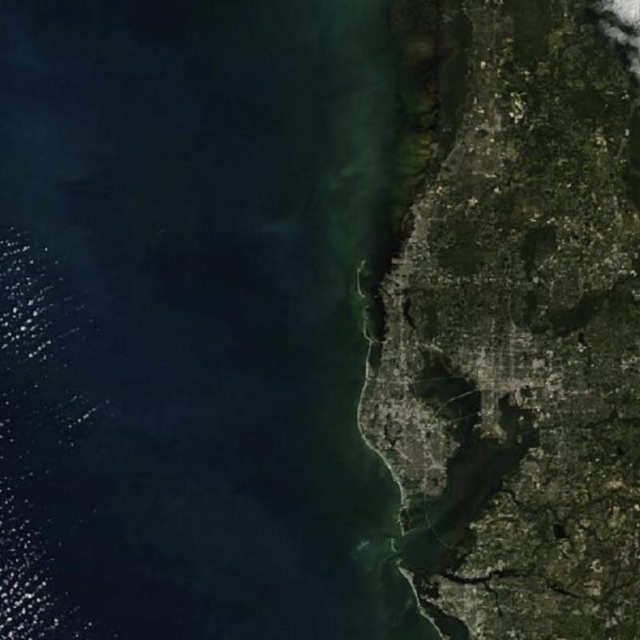 Deep, clear water
Green band: murky nearshore
River plume after rain
Clouds, not water
Bay water: greener, shallower